The Arkansas River Low Water Dams and Public Access/Recreational Improvement
Schematic Design and Cost Estimates
Apr. ’15 / 60 pages, 8 Appendices and Final Presentation
This document prepared in April 2015 summarizes the results of the schematic design process and defines the multiple project components that have been envisioned as a result of previous reports and studies related to developing the Arkansas River as a community resource for Tulsa County. This definition of project components was then used to develop cost estimates for the related improvements and associated requirements for implementation. Project components included in this schematic design process were derived from the 2009 Preliminary Project Management Plan (also available on this website) and include proposed low-water dams, public access, recreational amenities, bank stabilization, environmental improvements and other key elements.
The Arkansas River Corridor Master Plan
Preceded by decades of discussion about Arkansas River improvements and development potential, citizens, county and local officials, and the U.S. Army Corps of Engineers (USACE) produced and adopted the Arkansas River Corridor Master Plan in 2005.
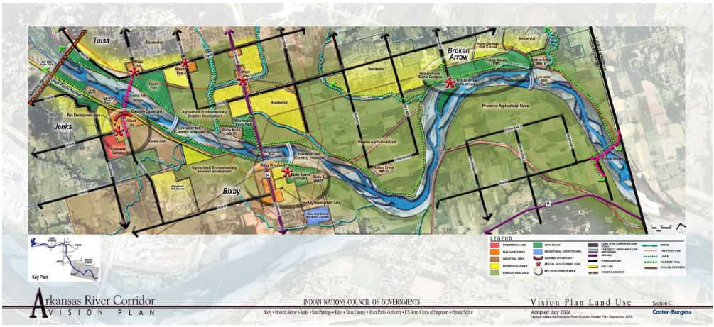
The three-part plan begins with the Vision Plan, completed in 2004, which, through an open, public process, identified the public’s ‘vision’ for Arkansas River improvements and potential development along the 42 miles of river in Tulsa County. Public input identified many desires and much support for improvements to the river. These desires included ‘more water in the river’; development and recreational areas at only appropriate areas along the corridor; better connections and access to the river; and conservation and improvement to the native riverine habitat wherever feasible.
The Arkansas River Corridor Master Plan further evaluated the Vision Plan concepts and recommendations, prepared conceptual plans for potential development areas, and prioritized locations of new low-water dams along the river corridor.
In 2006, the USACE and Tulsa County continued the evolution of the Master Plan by beginning the collection of seasonal environmental data from the corridor that will be required for the Environmental Permitting process. USACE and the Tennessee Valley Authority (TVA) also studied the river system and the proposed low-water dam locations, and performed more detailed analyses of their impact and feasibility. This third phase of the master planning process was completed in early 2009 with the completion of the Arkansas River Corridor Ecosystem Restoration Plan.
The Master Plan implementation continues to progress with the development of several projects contained in the Master Plan. These include the Feasibility Study of the Corridor that is focusing on the implementation of the proposed Sand Springs Low Water Dam (water control structure) and preparing a corresponding Environmental Assessment for the project currently in process by the Corps of Engineers; the permitting and funding of improvements to the existing Zink Dam to add recreational features, new gates for fish passage and sediment management, roller mitigation to reduce existing hazards of the current dam, and an Environmental Assessment and associated environmental improvements; and preliminary design and 404 permitting of the construction of the South Tulsa/Jenks Low Water Dam (the 404 permit application is currently under review by the Corps of Engineers). The original concepts continue to be refined as studies assess the River and the proposed project designs.
Documents of the Master Plan
Below are the documents that form the Arkansas River Corridor Master Plan for the 42 miles of Arkansas River flowing through Tulsa County.
Phase I — Vision Plan
Aug. ’04 / 23 pages and 3 attachments
This is the big-picture vision developed by stakeholders and citizens. Summaries and sketches describe short-term, mid-term, and long-term (over ten years) projects envisioned for the 42 miles of Arkansas River in Tulsa County. The scope of projects is inclusive, from low-water dams to riverside development.
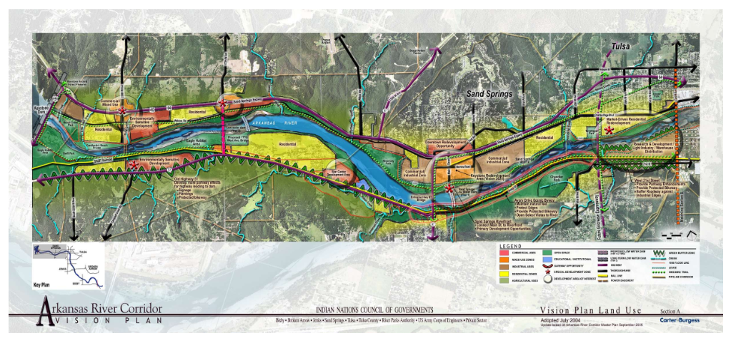
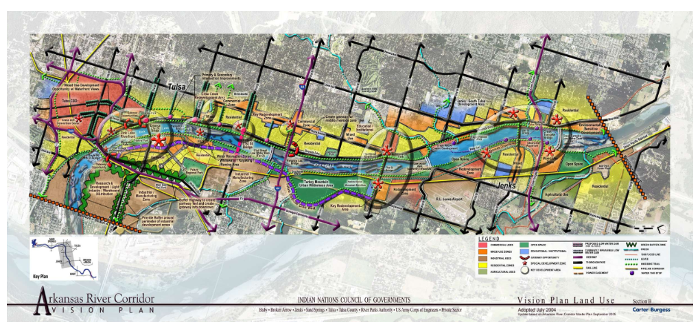
Sections of the Arkansas River and Their Land Use:
Phase II — Arkansas River Corridor Master Plan
Oct. ’05 / 283 pages and 12 appendices
Prepared for the Indian Nations Council of Governments (INCOG) and the Corp of Engineers, this study presents the history and habitats of the River. It evaluates, in detail, the opportunities and constraints of the proposed Vision Plan projects. The Master Plan presents potential locations of new low-water dams and conceptual development and recreation areas along the banks of the corridor. The Master Plan is presented in three files and 13 appendices, for easier downloads.
Phase III — Ecosystem Restoration Plan
Feb. ’09 / 76 pages and 5 environmental data reports
This study provides the baseline environmental data for the river corridor, including seasonal data collection for flora and fauna, water quality, and endangered species, and the initial cultural resources inventory and evaluation. Specifically addressed are ecosystem restoration needs and recommendations for low-water dam design and operation.
Phase IV — Preliminary Project Management Plan
Feb.’10 / 58 pages plus 23 appendices & ’11 USGS Sediment Study
This Preliminary Project Management Plan addresses guidelines and procedures for the next phase of the Arkansas River Corridor Projects, and serves as the basis for the final Project Management Plan. It includes reports and technical documents prepared for the river corridor, a project schedule and recommendations for further studies. The report identifies opportunities, problems, and constraints associated with three proposed low-water dams (Sand Springs, South Tulsa/Jenks and Bixby) and the existing Zink Dam modifications.
Arkansas River Corridor Feasibility Report and Integrated Environmental Assessment
Mar. ’18 / 181 pages plus appendices
This Feasibility Report, completed by the United States Army Corps of Engineers (USACE), Tulsa District, presents the potential for ecosystem restoration opportunities along a 42-mile corridor of the Arkansas River in Tulsa County. The river has served as an important habitat for the nation’s wildlife that live, breed, and migrate through the Arkansas River ecosystem. This study evaluated the components of the 2005 Arkansas River Corridor Master Plan and determined that there is a Federal interest that aligns with the USACE goal of a healthy ecosystem structure and function along the Arkansas River.